The historic Rose Creek salt marsh and wetlands stretched from what is today’s Kendall-Frost Marsh almost to the I-5 southbound on ramp on Mission Bay Drive across the northeast corner of Mission Bay and into what are now schools and residential areas. In the 1950s and 1960s, the City of San Diego destroyed these and other wetlands in Mission Bay. Over 4,000 acres of nutrient rich habitat for wildlife, migratory and local birds, as well as fish, and mud creatures that are at the bottom of the food chain were destroyed. For over 30 years, community groups and the City of San Diego have been planning on how to restore, revision, and plan for the area of Mission Bay near the mouth of Rose Creek.
Since the 1850s, 90 percent of California’s coastal wetlands have been destroyed.
The City of San Diego is planning to amend the Mission Bay Master Plan and is proposing a patchwork of wetlands to replace the fully function wetland complex that was destroyed. Read their plan here. However, the City of San Diego is ignoring its own Climate Action Plan by failing to model sea-level rise. The Mission Bay Park Master Plan calls for an additional 80 acres of wetlands remaining in 2100. The ReWild Mission Bay Coalition feasibility study models sea-level rise and has identified the amount of habitat that must be restored now to insure wetlands survive climate change driven sea-level rise. And the answer is we need more habitat to protect birds, fish, and other species.
We need your help in letting the City of San Diego know that wetlands matter and only larger contiguous stretches of restored wetlands and upland habitat will provide our grandchildren and their grandchildren with access to coastal salt marshes.
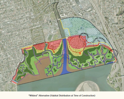
The Friends of Rose Creek supports the ReWild Mission Bay “Wildest” plan shown below.

Please let the City of San Diego know that you want more restored wetlands. If you have specific questions about the two separate plans, please email us and we will be happy to answer any questions you may have.
Please note that neither the City’s plan, nor ReWild Mission Bay’s plan removes the youth sports fields. Both plans maintain large amounts of land dedicated to active recreation like softball, soccer, tennis and golf.
The Friends of Rose Creek respectfully request you contact the City of San Diego Planning Department and make your voice heard. Comments can be submitted here.
DEADLINE FOR COMMENTS: Thursday, April 20
Don’t know what to say? Feel free to use any of these critical statements as is or in formulating your thoughts:
- Wetlands provide opportunity for recreational experiences in coastal salt marshes that are not currently available in Mission Bay Park including kayaking/canoeing/stand up paddle boarding in a coastal salt marsh as well as bird and other wildlife watching.
- The California coastal salt marsh is a distinct and valuable natural resource within the Coastal Zone that is of vital and enduring interest to all people and exists as a delicately balanced ecosystem that supports San Diego’s fishing industry, segments of our tourism industry, and our quality of life.
- In order to provide equitable access, salt marshes must be located in accessible spots of San Diego. Mission Bay Park has a level of public transit access that is not available for many other salt marshes in the county.
- For millennia, local tribal nations engaged with the salt marshes that once existed throughout much of Mission Bay. The salt marsh plants, birds, wildlife, and fish are what constitute re-connection, not access to a man-made park.
- The ReWild Mission Bay’s “Wildest” plan is the only plan to date that has incorporated sea-level rise modeling.
- Currently two public schools, military housing, and residential neighborhoods along the remaining fragments of the historic Rose Creek salt marsh are at risk from sea-level rise with Mission Bay High School most at risk.
- Enough upland habitat needs to be created to provide a place for the lower and mid-level salt marsh to migrate inland as sea levels rise. This is the most cost-effective and studied solution that will increase resilience to climate change and mitigate the sea level rise impacts already occurring, let alone the projected 1-2 meters in the City of San Diego’s draft sea-level rise assessment.
- The California Coastal Commission projects as much as a 66-inch increase in sea level along segments of California’s coast by the year 2100.
- The California Coastal Act notes that “the scenic and visual qualities of coastal areas shall be considered and protected as a resource of public importance.”
- In the context of Mission Bay, multi-modal travel includes watercraft, foot travel, and bicycling.
- By increasing the acreage of natural habitats, more opportunities will be created for active (kayaking, fishing, etc.) and passive (bird watching, exploring the daily changes in the salt marsh) recreation without threatening the sustainability of these natural habitats.
- Greater acreage of natural habitats provides more people access to coastal wetlands. Furthermore, appropriately situated and raised boardwalks can allow land-based visitors to explore nature up close and personal.
Comments can be submitted here.
0 Comments