Since the 1850s, 90 percent of California’s coastal wetlands have been destroyed.
The historic Rose Creek salt marsh and wetlands stretched from what is today’s Kendall-Frost Marsh almost to the I-5 southbound on ramp on Mission Bay Drive across the northeast corner of Mission Bay and into what are now schools and residential areas.
In the 1950s and 1960s, the City of San Diego destroyed these and other wetlands in Mission Bay. Over 4,000 acres of nutrient rich habitat for wildlife, migratory and local birds, as well as fish, and mud creatures that are at the bottom of the food chain were destroyed. These creatures support our sport and commercial fisheries as well as more visible wildlife.
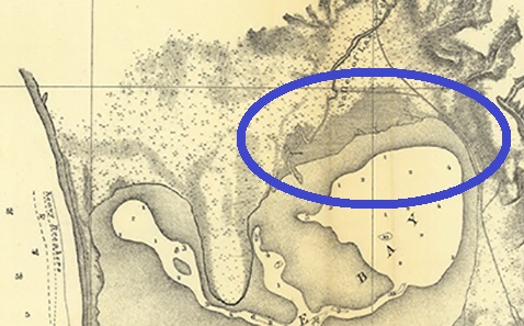
1857 Topo map showing the Historic Rose Creek Salt Marsh in the dark shaded area with the blue circle. The peninsula to the west (left) is Crown Point. The line on the east (right) is the railroad tracks.
We are asking for a tiny portion of that to be restored. For over 30 years, community groups and the City of San Diego have been planning on how to restore, revision, and plan for the area of Mission Bay near the mouth of Rose Creek.
The Friends of Rose Creek are part of the ReWild Mission Bay efforts to restore wetlands in the northeast corner of Mission Bay with the goal of having 80 additional acres of tidal salt marsh in the year 2100. This only restores 1/3 or less of the historic Rose Creek Salt Marsh and wetlands complex that existed before the creation of what is now called “Mission Bay Park.”