Anyone can participate in the King Tides Project! All you need is a cell phone or digital camera and access to a tidally-influenced shoreline.
 The highest high tides come to California during the winter months when they combine with the winter storm season. The term “King Tide” describes an especially high winter tide when the sun, the Earth, and the moon all line up.
The California King Tides Project helps us visualize future sea level by observing the highest high tides of today and how those tides interact with our coastal infrastructure, recreation areas, and ecosystems.
The King Tides around Mission Bay near Rose Creek will take place on:
- Sunday, November 15 at approximately 8:20 a.m.The Friends of Rose Creek will hosting a King Tides event
- Monday, November 16 at approximately 9:00 a.m.
- Sunday, December 13 at approximately 7:20 a.m.
- Monday, December 14 at approximately 8:00 a.m
- Tuesday, December 15 at approximately 8:45 a.m.
Feel free to join us on Sunday, November 15 or document the Creek at one of these times as well.
For those who want to do this on their own, here are locations that non-motorized vehicles ore pedestrians can access with nearest parking indicated.
From the Mike Gotch Bridge
From the Mike Gotch Bridge over the Rose Creek Inlet 32°47’53.3″N 117°13’15.4″W (32.798137, -117.220934) capturing both upstream and downstream. This is on a bike\pedestrian bridge. For those who want to drive to the location, 2606 N Mission Bay Dr, San Diego, CA 92109 – plenty of parking on south side of North Mission Bay Drive in this area.
From the Grand Avenue Bridge/Undercrossing
From the Grand Avenue Bridge OVER the Rose Creek Salt Marsh or the bicycle path UNDER the Grand Avenue along the Rose Creek Salt Marsh 32°48’07.1″N 117°13’19.7″W (32.801958, -117.222143). Parking is available at 2475 Grand Ave, San Diego, CA 92109 or 2639 Grand Ave, San Diego, CA 92109
From the Garnet Avenue Bridge/Undercrossing
From The Garnet Avenue Bridge OVER the Rose Creek Salt Marsh/Fresh Water Riparian Area or the bicycle path UNDER the Garnet Avenue Bridge along the upper Salt Marsh and lower fresh water creek 32°48’19.3″N 117°13’20.8″W (32.805372, -117.222441). Parking is at the Rose Creek Cottage 2525 Garnet Ave, San Diego, CA 92109 on the west bank of the creek on Garnet Avenue.
For Kids
Download the Kids King Tides Science Journal in PDF format and help the next generation engage in Citizen Science. Find the journal in English or Spanish. From in person observations to the California coastal webcam there is something for everyone to do even if you don’t live near the coast.
Sea Level Rise
It’s important that we learn about and communicate the impacts of sea level rise so that we can responsibly manage our coast today and in the future. Sea level rise is caused by increasing carbon dioxide in our atmosphere, which acts like a blanket trapping in heat that would otherwise escape. When we burn fossil fuels (such as coal, oil, or natural gas), we add more carbon dioxide, thickening this blanket and warming the planet’s atmosphere and the ocean. Sea level rises as glaciers and ice sheets melt into the ocean and because water expands in volume as it warms. Increases in global sea levels have been recorded by tide gauges since the late 1800s, and more recent observations have been collected by NASA satellites.
California will be greatly impacted by sea level rise. San Francisco, for example, is projected to see a rise of between 1.1 feet and 2.7 feet by 2050. By the year 2100, there’s a potential for more than 10 feet of sea level rise depending on how quickly we
curtail our use of fossil fuels and if there is extreme melting of the West Antarctic ice sheet. During King Tides, we can get an idea of what a rise in sea level of about one foot will look like in our coastal communities.
Instructions
 King Tides Photos
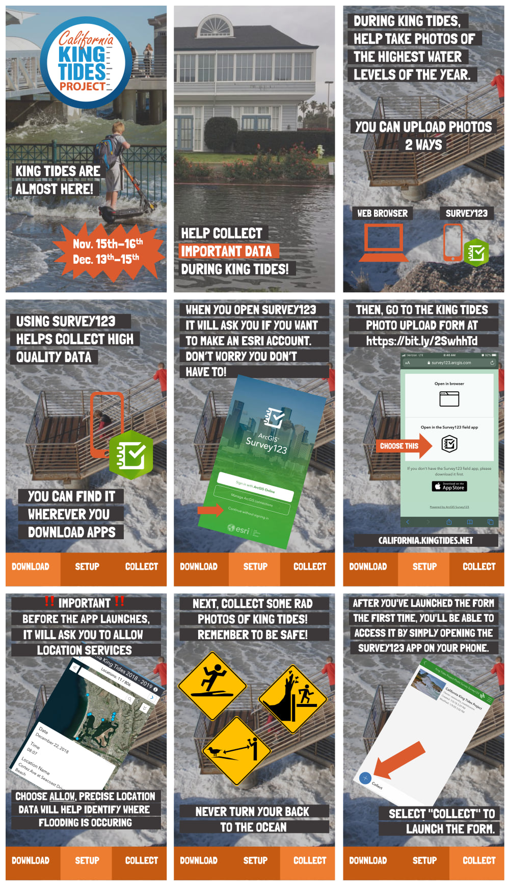
Participants in the King Tides Project take photos of these highest of high tides and upload them on the King Tides website at california.kingtides.net. Participants can also share photos and video on social media using #kingtides. These photos help document current flood risk, visualize the impacts of future sea level rise, ground-truth climate change models, and serve as a living record of change for future generations. The photos may be used in presentations, exhibitions, websites, and publications; for research and planning; and by students and educators learning about our world.
The California King Tides Project is a partnership of government and community organizations,
and part of a global network of King Tides initiatives.
Visit california.kingtides.net to learn more about King Tides, to see photos from past King Tides, to access lessons for students and educators, and to get instructions on how to upload your photos.
california.kingtides.net
twitter.com/ca_king_tides instagram.com/californiakingtides facebook.com/californiakingtides
Join the Friends of Rose Creek as we document the King Tide at the Rose Creek Salt Marsh and Estuary
1 Comment
Laurie carlock · November 3, 2020 at 10:27 AM
Thanks for putting this important info together in a user friendly way…!